High-Resolution Aerial Imagery & Location Intelligence
AURIN Provides Hard-to-Get Data for Researchers

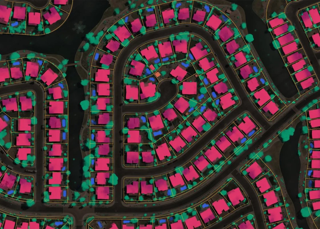
AURIN has secured access to national-scale aerial imagery and spatial data from Nearmap for researchers, industry professionals, and decision-makers. Nearmap delivers high-resolution aerial imagery and rich location intelligence that provides a clear, current view of the world on the ground. Updated frequently and available on demand, Nearmap empowers researchers and professionals to make confident decisions backed by reliable, real-world evidence. See patterns, progress, and change that others miss. Whether you’re embarking on infrastructure projects or envisioning the cities of tomorrow, Nearmap data advances your work with accuracy and consistency — because the truth is in the details.
Nearmap provides a range of geospatial data products designed primarily for property-level and fine-scale spatial analysis. These products are suitable for a wide range of urban and regional research applications.
Available product categories include:
Vertical imagery
High-resolution aerial imagery captured from a nadir (top-down) perspective.
Oblique imagery
Multi-angle imagery enabling detailed visual interpretation of buildings and urban form.
3D products
Including point clouds, textured meshes, and elevation models supporting three-dimensional analysis and visualisation.
AI-derived datasets
Feature-extracted datasets derived from imagery (availability subject to request scope).
Detailed information on content offerings, including spatial resolution, accuracy, capture methodology, coverage, and known artefacts, is available via Nearmap product documentation.
To support early exploration and feasibility assessment, researchers can request access to sample Nearmap data layers covering a defined area of metropolitan Adelaide.
The sample dataset collection will include:
Digital Surface Model (DSM) and Digital Terrain Model (DTM)
Raster elevation datasets representing terrain with and without above-ground features.
True Ortho imagery
Orthorectified aerial imagery with geometric distortions removed, suitable for accurate spatial measurement and mapping.
3D point cloud and textured mesh datasets
Detailed representations of terrain and built form to support immersive visualisation and three-dimensional analysis.
These datasets are provided in standard geospatial formats to support integration with common GIS, modelling, and visualisation tools.
Note: Sample data access is currently unavailable. A link and further instructions will be provided once enabled.
Nearmap data products can support a broad range of research activities, including (but not limited to):
Urban and regional planning analysis
Transport and mobility infrastructure assessment
Built-environment and land-use change detection
Environmental and landscape analysis
Scenario modelling and three-dimensional visualisation
While highly detailed, Nearmap products are designed primarily for property-scale and neighbourhood-scale analysis, and may not be suitable for all large-area or long-term temporal studies.

High-resolution imagery to monitor beach density, evaluate environmental hazard risks, and strategically deploy lifeguards to prevent drownings.
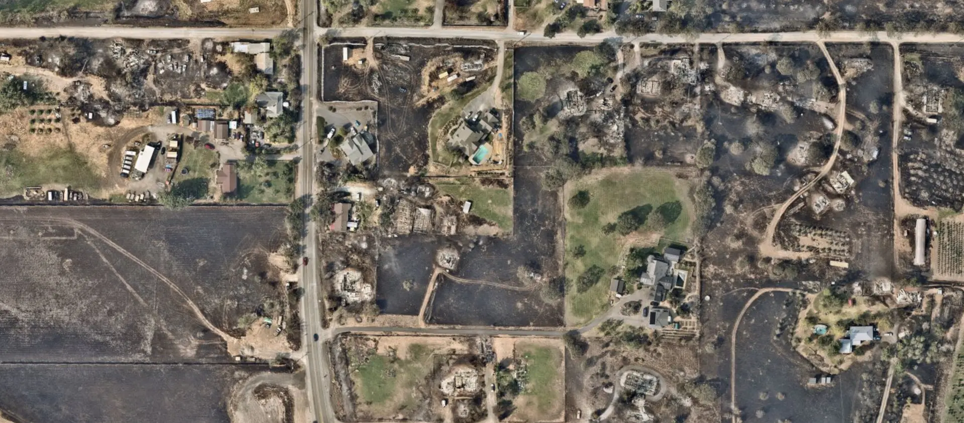
Analyse how fires spread, assess structural damage, track rebuilding efforts, and design fire-resilient urban forestry in affected cities.

AI-driven data to track spatio-temporal construction trends.
Under the collaboration agreement:
Researchers do not have direct access to Nearmap platforms or backend APIs.
Instead, researchers describe the data they require, and AURIN extracts and delivers the approved datasets through a secure delivery mechanism.
When submitting an application, it is essential to provide clear and specific information, including:
Product or layer names
Date(s) or preferred capture windows
Data frequency (e.g. single capture, quarterly, annually)
Spatial extent (study area boundaries)
Use the application link at the end of this page to submit a request.
AURIN currently supports limited data volumes per individual application, typically equivalent to the size of a small number of Local Government Areas (LGAs).
These limits depend on:
Number of layers requested
Product types (e.g. imagery vs 3D products)
Requested data frequency
As a result, some large-scale or data-intensive research projects may not be feasible under the current arrangement. Early discussion with AURIN staff is strongly recommended.
At this stage, access to the Nearmap data application page is restricted to approved users only. If you are interested in applying for Nearmap data access but you do not currently have the passcode to the application form, please contact AURIN to discuss your research project and eligibility. An AURIN team member will advise on next steps and, where appropriate, facilitate access to the application process.
Contact us to learn more about accessing the NearMap offerings.